










Executive Overview
For generations, the majestic chasms of the Grand Canyon have stood as Earth’s most vivid open-air textbook, inviting scientists and tourists alike to gaze deep into the planet’s turbulent past. Conventional geological wisdom long held that the iconic canyon was primarily sculpted by the relentless, erosive power of the Colorado River over the last six million years. However, a groundbreaking international study led by researchers at the University of Southampton has completely upended this narrative, revealing a prehistoric ghost landscape of astonishing proportions.
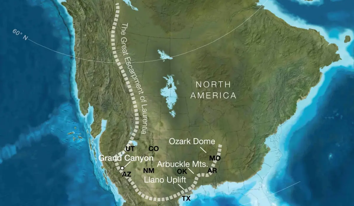
According to the new research published in the journal Geology, scientists have uncovered compelling evidence that an immense ancient cliff system—a towering "great escarpment"—rose across western North America roughly 800 million years ago. Standing nearly a kilometer high and stretching across thousands of kilometers, this colossal geological barrier was born from the violent tectonic fractures that ripped apart the ancient supercontinent Rodinia.
Crucially, this ancient escarpment acted as a continental conveyor belt of erosion, steadily stripping away up to eight kilometers of overlying rock layers long before the modern Colorado River ever took its first carved bite into the landscape. This massive erosional event finally dragged the canyon’s deep crystalline basement rocks to the surface, offering a transformative missing puzzle piece in our understanding of Earth’s crustal evolution.
Furthermore, this discovery directly addresses one of geology’s most enduring and perplexing enigmas: the Great Unconformity. This notoriously mysterious gap in the geological record spans more than a billion years of missing history within the Grand Canyon’s walls. By introducing the concept of a migrating, continental-scale escarpment driven by rifting and breakup, the research team has successfully reconciled how vast quantities of ancient rock vanished into the geological ether.
Spanning an interdisciplinary effort across the United Kingdom, Germany, and the United States, this study not only reshapes our comprehension of North America’s formative years but also provides a dynamic framework for interpreting similarly enigmatic continental interiors worldwide. By bridging the gap between modern active landscapes—such as the Great Escarpments of South Africa and Brazil—and deep-time tectonic history, geologists are finally beginning to read the torn pages of Earth’s deepest history.
Detailed Chronology: The Billion-Year Biography of a Lost Landscape
To understand the magnitude of the University of Southampton’s findings, one must journey back in time across a sweeping, multi-stage chronology that spans over a billion years of planetary evolution.
Phase 1: The Accumulation of Deep Crust (2 Billion to 1 Billion Years Ago)
The foundational chapters of the Grand Canyon’s deep interior preserve a history stretching back roughly two billion years. During this primordial epoch, ancient volcanic arcs, colliding tectonic plates, and deep-seated magmatic processes fused together to forge the robust crystalline basement rocks that now anchor the floor of the canyon. Yet, for reasons that have baffled generations of geologists, more than half of the subsequent rock record over the next billion years is completely absent. This staggering hiatus is the core of the Great Unconformity—a globally recognized geological boundary where flat-lying Cambrian sedimentary layers sit directly atop ancient, highly deformed igneous and metamorphic rocks, with a multi-hundred-million-year gap sandwiched invisibly between them.
Phase 2: The Breakup of Rodinia and the Rise of the Megacliffs (800 Million Years Ago)
Around 800 million years ago, the supercontinent Rodinia—a massive landmass uniting most of Earth’s continental blocks—began to tear itself apart under immense tensional tectonic forces. As the continental crust stretched, thinned, and fractured along the future western margin of North America (ancient Laurentia), localized tectonic uplift generated massive relief.
It was within this crucible of continental rifting that the researchers believe a vast "great escarpment" formed. Towering approximately one kilometer in height and stretching continuously over thousands of kilometers, this formidable topographic boundary cut across a swath of the North American continent that today encompasses modern-day Arizona, Utah, Idaho, Wyoming, Colorado, Texas, Oklahoma, Arkansas, Missouri, and Illinois.
Phase 3: The Migrating Escarpment and Mega-Erosion (700 to 500 Million Years Ago)
Once established, this towering mountain rim did not remain static. Over tens of millions of years, relentless subaerial weathering, episodic rainstorms, and slope instability systematically attacked the face of the escarpment. As the cliff edge weathered, structural retreat forced the giant topographic boundary to slowly migrate inland.
Through sophisticated landscape evolution modeling combined with plate tectonic reconstructions, the research team calculated that this protracted erosional retreat stripped an astonishing five to ten kilometers—and in some locations up to eight kilometers—of rock material from the region. This massive volume of sediment was swept away by ancient drainage networks, dumping colossal amounts of detritus into bordering ocean basins.
By systematically planing away these thousands of meters of overburden, the migrating escarpment effectively dragged the deeply buried crystalline basement rocks closer to the surface. This monumental denudation set the precise stage for the later deposition of shallow marine sediments during the Neoproterozoic and early Paleozoic eras, directly establishing the physical parameters of the Great Unconformity.
Phase 4: Pre-Cambrian to Modern Sculpting (500 Million Years Ago to Present)
Long after the ancient escarpment had flattened and weathered into subdued relief, the stage was set for subsequent geological cycles, including fluctuating sea levels that swept across the continent before the explosive diversification of complex life in the Cambrian explosion. Yet, the deep foundation work—the exhumation of the ancient basement rocks—had already been accomplished by the ancient escarpment nearly a billion years before.
Fast forward to roughly six million years ago, and the modern Colorado River seized upon this preexisting structural and topographic framework. Utilizing the softened, fractured, and previously unroofed pathways of the crust, the river initiated the rapid down-cutting and canyon-carving processes that ultimately exposed the awe-inspiring gorge observed by millions of travelers today.
Supporting Context & Metrics: Reconstructing Lost Worlds
Investigating events that transpired hundreds of millions of years ago requires an innovative synthesis of hard data, advanced computing, and comparative geomorphology. The international research team—featuring scientists from the University of Southampton, the GFZ Helmholtz Centre for Geosciences, the University of Potsdam, and the University of Illinois Urbana-Champaign—relied on a multi-pronged methodological approach to resurrect this lost North American landscape.
Quantifying the Missing Rock
One of the most robust validations of the escarpment model comes from quantitative mass-balance calculations and thermochronology. For decades, geologists noted an irreconcilable discrepancy: thermal history data and missing strata metrics indicated that extensive sections of the southwestern United States had shed between five and ten kilometers of vertical rock thickness prior to the deposition of younger sedimentary layers.
Traditional river erosion models struggled to account for such uniform and deep denudation across vast interiors lacking high mountain ranges. However, the Southampton-led team demonstrated that a migrating continental escarpment driven by rifting naturally produces the exact magnitude and spatial distribution of erosion required to account for the missing five to eight kilometers of crust.
Modern Analogs: Looking Across Space to See Through Time
To visualize how an ancient North American escarpment operated, the researchers drew direct comparisons with modern, active tectonic landscapes across the Southern Hemisphere. Continental margins in regions such as South Africa, Brazil, India, and Antarctica feature dramatic, long-lived great escarpments born from continental breakup—such as the breakup of the ancient supercontinent Gondwana.
| Feature / Metric | Ancient North American Escarpment (Rodinia Breakup) | Modern Comparative Analogs (e.g., South Africa / Brazil) |
|---|---|---|
| Estimated Height | ~1 Kilometer | Up to 1.5 Kilometers |
| Spatial Extent | Thousands of kilometers across Laurentia | Thousands of kilometers along continental margins |
| Primary Driver | Tectonic rifting and breakup of Rodinia | Continental fragmentation during Gondwana breakup |
| Erosional Impact | 5 to 8 kilometers of vertical rock removed | Significant ongoing scarp retreat and coastal denudation |
| Geological Consequence | Exhumation of basement rocks, formation of the Great Unconformity | Creation of elevated inland plateaus and deeply eroded coastal plains |
By studying how these modern escarpments retreat inland over tens of millions of years, shedding massive quantities of sediment and progressively unroofing underlying basement complexes, the researchers gained a reliable physical template. This comparative methodology allowed them to validate computer simulations of plate tectonics against the physical realities observed in Arizona’s rock layers today.
Official Statements and Expert Insights
The study, published in the peer-reviewed journal Geology, offers profound implications for academic circles and field geologists alike, shifting how researchers conceptualize continental interiors.
Lead author Professor Thomas Gernon, Professor of Earth Science at the University of Southampton, emphasized the paradigm-shifting nature of the research in official university releases:
"Our paper suggests the Canyon’s basement rocks were progressively brought to the surface as part of an immense escarpment that developed during the breakup of an ancient supercontinent. The findings also shed light on the formation of the Great Unconformity, a mysterious gap in the rock record that spans over a billion years."
Addressing the spatial scale of the geological forces involved, Professor Gernon noted how widespread the phenomenon truly was across the ancient North American core:
"This long-lived tectonic landscape provides a missing piece in understanding why erosion associated with the Great Unconformity varies so dramatically across the southwestern US. Our work suggests that tectonic uplift related to continental rifting and breakup created both steep slopes and high ground, providing the mountainous terrain that rivers and glaciers could readily erode."
Furthermore, the researchers highlight that the physical presence of this mountainous rim did not merely scrape away rock—it actively engineered the surface environment of ancient North America. By establishing a prominent, long-lived topographic barrier around western Laurentia, the escarpment fundamentally dictated drainage pathways, controlled sediment delivery systems to surrounding marine basins, and regulated marine transgressions across the interior plains just prior to the Cambrian explosion.
Professor Gernon summarized the broader global implications for Earth sciences:
"Today’s escarpments in Africa, Brazil, India and Antarctica provide windows into the forces that shape continents over hundreds of millions of years. By comparing the Grand Canyon’s ancient history with active landscapes like the Great Escarpment of South Africa, we’re able to see North America’s most iconic geologic landmark in an entirely new light. Our findings could help geologists reinterpret other ancient continental interiors where similarly large gaps occur in records, offering a better understanding of how Earth’s continents have changed over hundreds of millions of years."
Future Outlook: Reinterpreting the Global Geological Record
The discovery of this 800-million-year-old megacliff system marks the end of a long-standing geological mystery, but it simultaneously opens exciting new avenues for scientific inquiry across the globe.
For generations, researchers examining mysterious, continent-wide gaps in rock strata—such as the Great Unconformity—were constrained by local or purely fluvial models that failed to explain the massive regional scale of missing crust. With the validation of the rifting-induced escarpment model, geologists now possess a powerful new conceptual tool.
In the immediate future, researchers plan to apply this integrated framework—combining plate tectonic modeling, thermochronology, and landscape evolution simulations—to other ancient cratonic interiors. Continents such as Australia, Scandinavia, and parts of Asia harbor similarly puzzling unconformities and ancient basement exposures that have long resisted straightforward explanation. By testing whether migrating great escarpments were a common byproduct of ancient supercontinent breakups, earth scientists hope to establish a unified global model for how continental crust is modified, weathered, and unroofed over deep geological time.
Ultimately, this study serves as a humbling reminder of the planet’s dynamic and relentless transformative power. The Grand Canyon, long celebrated as a masterpiece carved by water, is now recognized as the ultimate legacy of a forgotten mountain rim—a testament to ancient tectonic violence that rearranged a continent nearly a billion years before human eyes ever gazed into its breathtaking depths.