





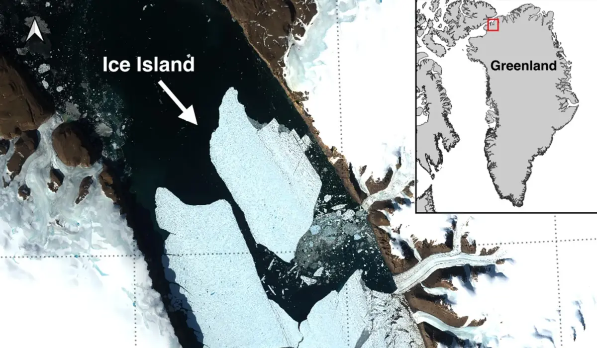
NORTHWEST GREENLAND — In a dramatic illustration of accelerating polar transformation, an international team of researchers has documented a monumental calving event at the Petermann Glacier in northwest Greenland. On August 4, 2026, the glacier shed a staggering 76.4-square-kilometer (29.5-square-mile) tabular ice island from its sprawling floating ice tongue.
This historic fracture represents the glacier’s largest single loss of floating ice since 2012 and marks the most significant Arctic calving event recorded since 2020. Generating a floating slab roughly comparable in surface area to Manhattan Island and reaching up to 150 meters (492 feet) in thickness, the event has triggered an immediate mobilization of polar researchers, maritime safety authorities, and climate modelers worldwide.
The discovery was brought to light by Adam Garbo, a doctoral researcher specializing in glaciology within the Department of Geography, Environment and Geomatics at the University of Ottawa (uOttawa). This breakthrough underscores the vital role of continuous satellite surveillance in monitoring the rapidly shifting dynamics of Earth’s northernmost ice systems.
Executive Overview: A Paradigm Shift in Arctic Ice Stability
The shattering of Petermann Glacier’s ice tongue is far more than a localized geographical curiosity; it is a clear indicator of the compounding vulnerabilities facing Earth’s cryosphere. As global temperatures continue to warm at rates disproportionately high in the polar regions, massive marine-terminating glaciers are increasingly subjected to structural fatigue caused by warming ocean waters below and rising atmospheric temperatures above.
The newly formed tabular iceberg—a monolithic block of compacted freshwater ice characterized by sheer vertical cliffs and a flat upper surface—broke away after years of visible, monitored deterioration. While tabular icebergs are a common geological feature of the Southern Ocean surrounding Antarctica, equivalent formations of this magnitude remain exceptionally rare in the Arctic.
This rarity transforms the Petermann calving event into a high-value natural laboratory. Glaciologists now have an unprecedented window of opportunity to observe the birth, trajectory, marine interaction, and eventual breakup of an enormous Arctic ice island in real-time. Yet, this scientific opportunity is tightly coupled with environmental and operational concerns. Massive drifting ice islands present long-term hazards to maritime navigation, northern ecosystems, and offshore infrastructure across the high-latitude shipping lanes of the Canadian Arctic and Northwest Passage.
Detailed Chronology: Anatomy of a Fracture
To understand how a landmass of this scale detaches from a glacier, researchers must rely on a continuous, multi-year archival timeline. The August 4 calving event was not a sudden catastrophe without warning; rather, it was the explosive culmination of years of structural weakening within the glacier’s foundational architecture.
Years of Growing Instability (2019–2025)
The roots of the 2026 event trace back through continuous satellite monitoring efforts initiated in 2019. For nearly seven years, an international consortium comprising the University of Ottawa, the University of Stirling, Environment and Climate Change Canada (ECCC), Lancaster University, and the University of Leeds maintained a round-the-clock vigil over the Petermann Glacier’s floating ice tongue.
Over this monitoring window, scientists watched anxiously as complex networks of fractures—known as rifts—began to propagate laterally across the ice tongue’s centerline. These rifts acted as systemic fault lines, gradually eating away at the structural integrity of the glacier.
"Petermann Glacier has long been one of Greenland’s largest remaining ice tongues," reflects Adam Garbo, lead identifier of the break. "We’ve anticipated this break for years, and seeing it finally happen is remarkable from a scientific perspective, yet sobering when you witness the sheer scale of ice loss."
The Final Hours: August 3–4, 2026
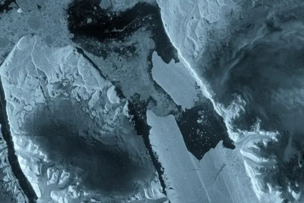
The final sequence leading to the separation of the 76.4 km² ice island unfolded rapidly across a span of 48 hours, captured entirely by advanced spaceborne radar and optical imaging systems.
- August 3, 2026: Images captured by the European Space Agency’s (ESA) Sentinel-1 radar mission revealed alarming structural changes. The central rifts had widened significantly, and high-resolution radar backscatter indicated that the connection points holding the massive tabular section to the main glacier body were under extreme tensile stress.
- August 4, 2026 (20:00 UTC): The tipping point was reached. Complete structural failure occurred along the eastern flank of the ice tongue. The immense tabular iceberg fully sheared away from the parent glacier, officially becoming an independent ice island adrift in the Petermann Fjord.
Supporting Context & Metrics: Deconstructing the Colossus
Evaluating the true magnitude of the Petermann Glacier calving event requires looking closely at the metrics defining the ice island and the broader health of the glacier system.
| Metric / Parameter | Measurement / Description |
|---|---|
| Date of Calving | August 4, 2026 (completed at ~20:00 UTC) |
| Surface Area of Ice Island | 76.4 km² (approximately equivalent to Manhattan Island) |
| Estimated Thickness | Up to 150 meters (492 feet) |
| Historical Context | Largest Arctic loss since 2020; largest Petermann loss since 2012 |
| Projected Future Losses | Two upcoming rifts expected to yield 94 km² and 84 km² blocks |
| Cumulative Impact | Total projected loss of ~254 km², reducing the ice tongue by 22% |
Why Arctic Ice Islands Matter
While Antarctica routinely sheds massive tabular icebergs—such as the famous A68 iceberg that broke off the Larsen C ice shelf in 2017—the Arctic environment differs fundamentally. Arctic ice shelves and floating tongues are typically smaller, more fractured, and subject to different climatic and oceanographic forcing mechanisms.
"While large, tabular icebergs are relatively common in the Southern Ocean that surrounds the Antarctic Ice Sheet, Arctic ice islands are far rarer," explains Dr. Anna Crawford of the University of Stirling, a co-researcher on the project. "By studying Arctic ice islands, we will gain knowledge that can be transferred across polar regions, helping us untangle the complex mechanics of how floating ice masses respond to atmospheric and oceanic warming."
The longevity of these ice islands is another critical area of study. Because they are exceptionally thick—in this case, reaching up to 150 meters—they possess a massive keel that extends deep into the water column. This causes them to interact profoundly with ocean currents, often grounding on shallow sea floors before breaking apart into smaller, more erratic bergy bits and growlers.
Official Statements and Expert Insights
The implications of the Petermann Glacier event stretch across multiple scientific and operational disciplines. Leading researchers and governmental authorities have emphasized the urgent need for ongoing interdisciplinary collaboration.
"Petermann Glacier has long been one of Greenland’s largest remaining ice tongues. We’ve anticipated this break for years, and seeing it finally happen is remarkable. Our focus now shifts to understanding the exact oceanographic and atmospheric triggers that accelerated the final hours of separation."
— Adam Garbo, PhD Student in Glaciology, University of Ottawa
The collaborative framework driving this research is designed to pool international expertise, combining glaciological field data, satellite remote sensing, and ocean circulation modeling.
"While large, tabular icebergs are relatively common in the Southern Ocean… Arctic ice islands are far rarer. By studying them, we will gain knowledge that can be transferred across polar regions, improving our predictive models for global sea-level rise."
— Dr. Anna Crawford, University of Stirling
Beyond academic inquiry, operational agencies are heavily focused on the immediate environmental and navigational fallout of the event.
"These are thick blocks of ice that can drift for years. Over time, they fracture into smaller, harder-to-track pieces that pose hazards to vessels and resource operations. Our mandate is to track these hazards meticulously to protect human life and maritime commerce."
— Dr. Abigail Dalton, Canadian Ice Service, Environment and Climate Change Canada (ECCC)
Future Outlook: Looming Instability at Petermann
If the scientific community hoped that the August 4 calving event would allow the Petermann Glacier to achieve a state of structural equilibrium, satellite data suggests otherwise. The forces destabilizing the glacier remain active, and the ice tongue’s ordeal is far from over.
The Next Wave: 94 km² and 84 km² Rifts Waiting to Break
Glaciologists monitoring the glacier via Sentinel-1 and other orbital assets have identified two additional massive rifts situated further up-glacier. These fault lines have been actively widening for years, mirroring the early stages of the rift that ultimately produced the Manhattan-sized ice island.
Projections indicate that these two sections are primed to detach in the near future. The first pending segment is estimated to measure approximately 94 square kilometers, while the second sits at roughly 84 square kilometers.
If both of these sections break away as anticipated, the cumulative impact of these three sequential calving events will remove an astounding 254 square kilometers of ice from the Petermann Glacier’s floating ice tongue. This cascading loss will effectively amputate roughly 22 percent of the entire ice tongue’s remaining surface area, drastically altering the geometry of the glacier and potentially accelerating the flow rate of the grounded ice sheet feeding it from behind.
Maritime Safety and the Long Road Ahead
As the newly liberated 76.4 km² ice island begins its slow, formidable journey out of the Petermann Fjord and into more open waters, institutional oversight will remain constant. Environment and Climate Change Canada, alongside international partners, will utilize advanced synthetic aperture radar (SAR) and tracking beacons to monitor every nautical mile of the ice island’s drift.
For Adam Garbo and his colleagues at uOttawa, the University of Stirling, ECCC, Lancaster University, and the University of Leeds, the work is entering a new phase. Combining orbital satellite imagery, high-altitude aerial surveys, and empirical oceanographic data, the research team aims to decode the complex feedback loops driving Arctic ice shelf retreat.
As the Arctic continues to warm at nearly four times the global average, events like the Petermann Glacier calving serve as both an urgent warning and an essential lesson in the rapid reshaping of our planet’s frozen frontiers.