





Executive Overview
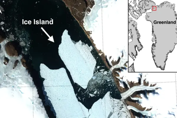
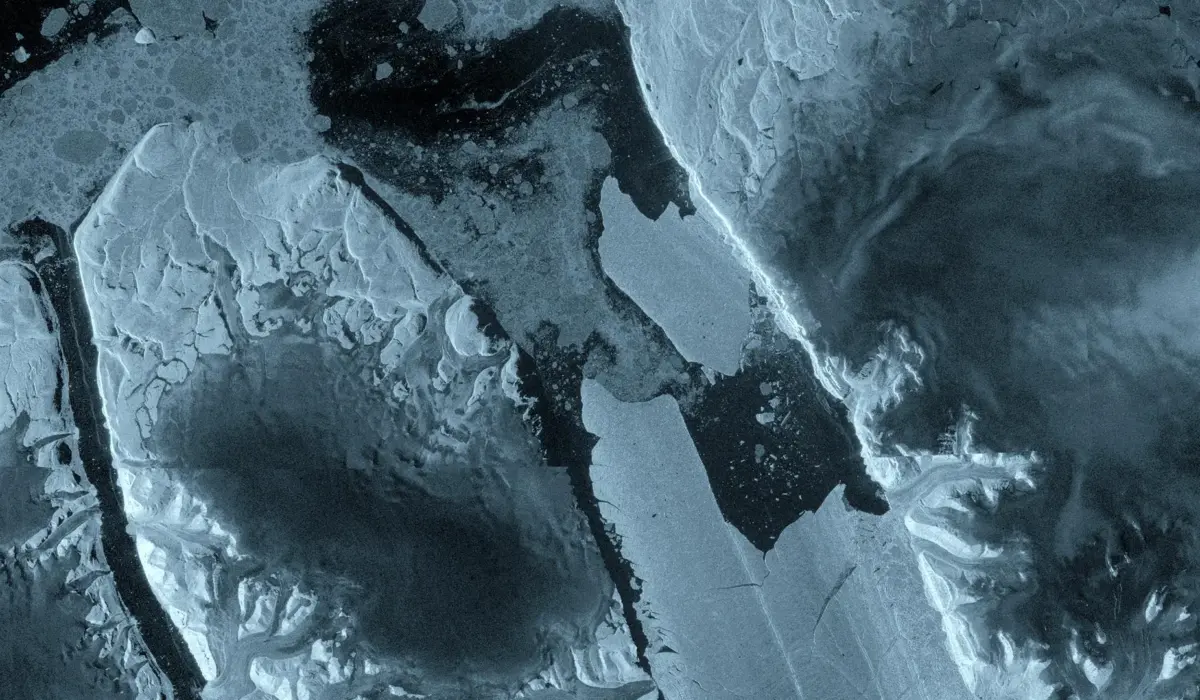
In the freezing expanse of northwest Greenland, a monumental fracture has redrawn the Arctic map. On August 4, 2026, a staggering 76-square-kilometer section of the Petermann Glacier’s floating ice tongue sheared away, plunging a colossal tabular iceberg into the dark waters of the Nares Strait. Captured in near-real time by Europe’s advanced Copernicus Sentinel-1 mission, this calving event marks the largest loss of floating ice for the Petermann Glacier since 2012 and stands as the most massive single ice-shedding occurrence recorded across the entire Arctic since 2020.
The newly born "ice island" is roughly equivalent in area to Manhattan and possesses a staggering thickness reaching up to 150 meters. While gigantic tabular icebergs are a frequent signature of the dynamic ice shelves hugging Antarctica, such monolithic masses remain exceptionally rare in the Arctic. This dramatic structural failure highlights the accelerating volatility of Earth’s polar environments, providing researchers with an unprecedented window into the mechanical stresses tearing apart the world’s northernmost ice systems.
The breakthrough was not merely observed; it was meticulously dissected. Powered by a fortuitous tandem phase between the newly launched Sentinel-1D satellite and its predecessor Sentinel-1C, an international consortium of glaciologists utilized synthetic aperture radar (SAR) and interferometry to track the glacier’s agonizingly slow, yet catastrophic, unraveling. Funded in part by the European Space Agency’s (ESA) FutureEO ARCTEX project, this multi-institutional collaboration—spanning the University of Ottawa, the Universities of Stirling, Lancaster, and Leeds, alongside the Canadian Ice Service—has turned the Petermann Glacier into one of the most thoroughly scrutinized frontiers of climate science.
Beyond its scientific resonance, the birth of this Arctic leviathan carries immediate practical repercussions. Government agencies, including Environment and Climate Change Canada, are locked in high-stakes monitoring protocols to track the iceberg’s drift. As this floating fortress drifts southward, it poses a creeping hazard to vital Arctic shipping lanes, indigenous marine corridors, and offshore infrastructure. This comprehensive report explores the chronology of the collapse, the technological marvels that captured it, the expert analysis behind the data, and the broader implications for global sea-level rise and polar marine security.
Detailed Chronology: Anatomy of a Collapse
The disintegration of the Petermann Glacier’s ice tongue did not happen overnight; it was the culmination of relentless physical forces operating beneath, within, and across the frozen expanse over a span of many months.
Spring Warnings: April Interferometry
The earliest clear warnings of structural failure emerged in April 2026. Utilizing advanced interferometric observations collected over the Petermann Glacier, researchers detected subtle yet alarming signs of internal deformation and burgeoning fractures webbing across the floating ice tongue. These radar-derived measurements provided a high-resolution, subterranean view of stress lines that had been developing quietly beneath the pristine surface.
For months, the international research team had been tracking the widening rifts. Yet, the true velocity of the decay remained hidden until the summer melt season applied its relentless pressure. The glacier, which had settled into a period of relative calm following major calving events in 2008, 2010, and 2012, was quietly reaching a structural tipping point.
The 48-Hour Terminal Phase
By early August, the glacial system transitioned from structural stress to outright failure. On August 3, 2026, synthetic aperture radar images beamed down by the Sentinel-1 mission revealed profound deterioration concentrated along the central spine of the ice tongue. The radar signatures exposed deep, wide-open fissures where the ice had begun to pull apart under the strain of ocean tides and internal thermal expansion.
Just twenty-four hours later, on August 4, the inevitable occurred. The massive 76-square-kilometer tabular iceberg completely severed from the glacier’s eastern flank. Because Sentinel-1 operates with C-band radar wavelengths, it remained completely unimpeded by the thick, swirling Arctic cloud cover and the perpetual twilight of the polar summer, capturing the exact moment of structural separation with crisp, unyielding precision.
The Looming Aftershocks
Alarmingly, glaciologists warn that this historic break may merely be the opening act. Analysis of ongoing rift propagation across the remaining shelf indicates that two additional major ice islands—estimated to cover approximately 97 square kilometers and 87 square kilometers respectively—are precariously close to detachment. As these existing rifts continue to widen and stitch their way across the balance of the floating tongue, the Petermann Glacier could shed even more of its mass in the near future, fundamentally reshaping the physical geometry of northwest Greenland.
Supporting Context & Metrics: Technology, Geography, and Science
Understanding the magnitude of the Petermann Glacier event requires an examination of the advanced satellite architecture that documented it and the broader geographic context of the Arctic cryosphere.
The Sentinel-1 Tandem Breakthrough
The unprecedented level of detail achieved during this event was made possible by a stroke of orbital good fortune: the commissioning phase overlap of the Sentinel-1C and Sentinel-1D satellites. This tandem configuration allowed researchers to gather one-day repeat synthetic aperture radar observations.
Typically, satellites revisit a specific polar grid every few days, but the one-day repeat cycle granted scientists an ultra-high-frequency temporal lens. This allowed researchers to construct intricate interferograms—composite images that map surface displacement by measuring phase differences in radar waves. For the first time, scientists could measure with sub-centimeter accuracy how cracks propagated across the ice shelf and how the surface of the tongue flexed and groaned in response to daily ocean tides in the critical hours leading up to the final break.
The ARCTEX Project and International Collaboration
The monitoring of the Petermann Glacier is spearheaded by an elite coalition of researchers under the umbrella of ESA’s FutureEO ARCTEX project. This international network bridges continents and disciplines:
- University of Ottawa (Canada): Leading critical structural analysis and field coordination.
- Universities of Stirling, Lancaster, and Leeds (UK): Providing advanced glaciological modeling, ice-ocean interaction studies, and interferometric data processing.
- Canadian Ice Service (Environment and Climate Change Canada): Overseeing operational tracking, risk assessment, and navigational safety protocols.
This multidisciplinary partnership has transformed raw satellite telemetry into actionable earth-system science, bridging the gap between orbital observation and ground-level environmental management.
Official Statements and Expert Analysis
The scientific community has responded to the Petermann calving event with a mixture of professional validation and profound concern over the state of the polar equilibrium.
Adam Garbo, a PhD student at the University of Ottawa who has spent years monitoring the glacier, reflected on the long-anticipated event:
"Petermann Glacier has long been one of Greenland’s largest remaining ice tongues. We’ve anticipated this break for years, and seeing it finally happen is remarkable. It’s a powerful reminder of how quickly these systems can change."
Dr. Anna Crawford of the University of Stirling highlighted the broader geographical significance of the phenomenon:
"While large, tabular icebergs are relatively common in the Southern Ocean around Antarctica, Arctic ice islands are far rarer. By studying Arctic ice islands, we will gain knowledge that can be transferred across polar regions. This is critical for understanding how the calving and deterioration of ice islands impact glacier dynamics, sea-level rise and the ocean environment."
Detailing the technical feat of capturing the collapse in near-real time, Molly Hammond, a PhD student from the University of Leeds responsible for processing the Sentinel-1 radar data, stated:
"The changes we observed on Petermann Glacier were occurring very rapidly in the lead-up to the iceberg calving event, so it was incredibly exciting to monitor the crack propagation with interferometry in near-real time. This has demonstrated the incredible value of one-day repeat synthetic aperture data."
Weighing in from the European Space Agency, Martin Wearing emphasized the systemic importance of continuous spaceborne monitoring:
"This type of large tabular iceberg is relatively rare in the Arctic, making this calving event a unique opportunity to study how such a vast ice mass drifts, evolves and eventually breaks apart. Satellite missions such as Sentinel-1 provide the systematic, long-term observations needed to track these changes, helping scientists better understand the processes driving calving and wider impacts on the polar environment, and ultimately the Earth system as a whole. Alongside Europe’s excellent Earth observation missions, we are pleased to see the ARCTEX project supporting this work and enabling further scientific investigation of the rapidly evolving Arctic."
Future Outlook: Tracking the Leviathan and Navigational Risks
As the dust—and ice—settles over the Nares Strait, the focus of the international scientific and operational community pivots from observation to tracking and mitigation.
Scientific Horizons: Decoding the Arctic Ice Island
The newly minted 76-square-kilometer ice island represents a natural laboratory. As it drifts away from its parent glacier, it will be subjected to warmer waters, wave action, and atmospheric melt. Researchers will deploy a suite of satellite sensors, aerial overflights, and oceanographic tracking beacons to follow its trajectory. By studying how this colossal block of ice fragments, melts, and interacts with ocean currents, scientists hope to refine predictive models concerning how Arctic ice shelves respond to shifting climatic baselines.
Furthermore, understanding the mechanics of Petermann’s calving sheds light on the stability of the entire Greenland Ice Sheet. While floating ice tongues do not directly contribute to sea-level rise when they melt (since they are already displacing ocean water), their loss can reduce the "buttressing" effect that holds back inland glacial ice. If the stabilizing tongue completely disintegrates, the flow rate of grounded ice pouring into the ocean can accelerate dramatically, contributing directly to global sea-level rise.
Operational Hazards: Shipping, Security, and Survival
On a more immediate, operational level, the birth of a Manhattan-sized ice island presents a severe hazard to maritime activities in the high north. Environment and Climate Change Canada is aggressively charting the iceberg’s drift path, evaluating potential threats to commercial shipping lanes, fishing fleets, and offshore industrial infrastructure operating in Canadian and Greenlandic waters.
Massive ice islands of this scale do not simply melt away in a season; they can persist in the ocean environment for years. As they drift, they progressively fracture into smaller, highly unpredictable tabular bergs and bergy bits. These secondary fragments are frequently difficult to detect via standard shipboard radar, particularly during periods of poor visibility or heavy sea states, posing a silent hazard to mariners.
Conclusion
The August 2026 fracture of the Petermann Glacier is more than a fleeting news item; it is a stark indicator of the rapid, sweeping transformations rewriting the rules of the Arctic. Through the lens of the Sentinel-1 mission and the dedication of international researchers, humanity has been granted an unfiltered look at the forces reshaping our planet’s frozen core. As the newly formed ice island drifts into the open sea, it carries with it both a warning about our changing climate and an urgent mandate for continued vigilance, scientific cooperation, and robust environmental stewardship.