











Executive Overview
The summer of 2026 will be etched into the climatic and environmental history of Western Europe as a turning point in the escalation of extreme wildfire events. In mid-July 2026, a series of catastrophic, fast-moving blazes tore through the Iberian Peninsula and southwestern France, ranking among the most destructive and expansive fire seasons either country has experienced in modern records. Driven by an explosive combination of anomalous hydroclimatic cycles, intense multi-week heat waves, and ferocious winds, the fires forced the emergency evacuation of hundreds of thousands of residents, obliterated hundreds of structures, and fundamentally altered vast swathes of protected and agricultural landscapes.
In Spain, the provinces of Ávila and Madrid became ground zero for a historically unprecedented conflagration. The Ávila blaze alone incinerated roughly 50,000 hectares (124,000 acres), easily eclipsing the previous year’s destructive fires in northern Spain and earning the grim distinction of being the largest single wildfire ever recorded in modern Spanish history. Concurrently, across the border in France, the Gironde Department west of Bordeaux suffered a devastating sequence of blazes that pushed the nation’s cumulative July burn scar past 90,000 hectares—the worst French fire season in decades.
Beyond the sheer physical devastation, the crisis was marked by terrifying atmospheric phenomena, including the first-ever documented pyrocumulonimbus (“fire cloud”) storm generated by a wildfire in France. This comprehensive report details the timeline of the July 2026 disaster, explores the perilous meteorological setup that primed the landscape, analyzes satellite data and official metrics, and evaluates the long-term outlook for a continent increasingly vulnerable to climate-accelerated disasters.
Detailed Chronology: How the Crisis Unfolded
The Spark and Rapid Expansion in Spain
The catastrophic sequence in Spain began during the third week of July 2026. NASA’s advanced Earth-observing satellites first detected thermal anomalies and billowing smoke plumes near the municipality of Burgohondo in the Ávila province on July 22 and July 23.
What began as localized ignitions under dry forest canopies quickly escaped initial containment efforts. Fueled by tinder-dry undergrowth and propelled by intense afternoon gusts, multiple independent fires broke out across neighboring provinces. By July 24, these separate blazes had aggressively merged into a monolithic mega-fire front. In less than 48 hours, the unified fire system had scorched a staggering 77,000 hectares—an uninterrupted swath of devastation roughly equivalent to the total land area of New York City.
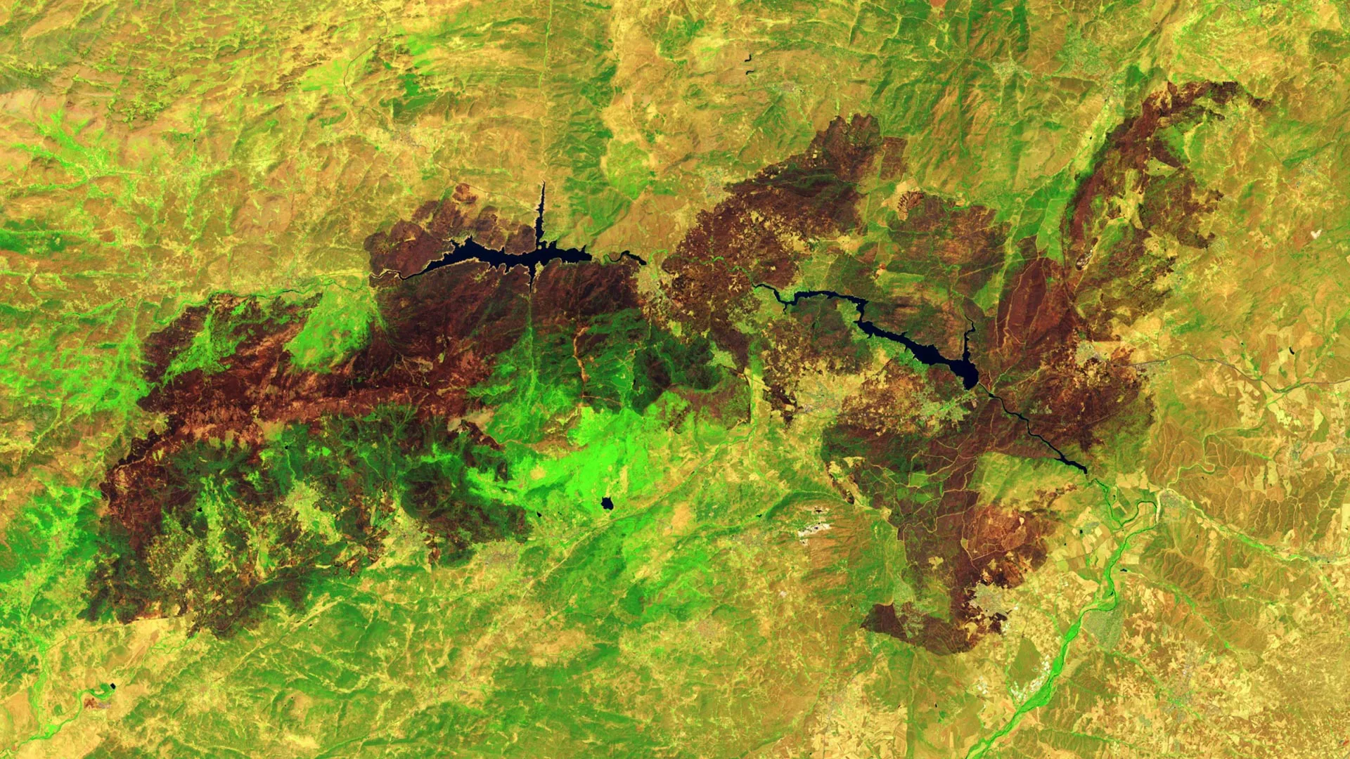
The firestorm raced through rugged terrain, threatening popular tourist corridors, residential zones, and critical infrastructure. Satellite imagery captured by the Landsat 9 satellite on July 29, 2026, revealed the staggering scale of the destruction around Burgohondo. In false-color infrared views, where healthy vegetation glows light green and burned earth registers as deep brown, the landscape bore the scars of an unsparing inferno. Vital regional reservoirs near the center of the impact zone, long serving as recreational hubs and ecological anchors, were ringed by charred earth where homes, local restaurants, campgrounds, and marinas had stood just days prior.
The Gironde Crisis in Southwestern France
While Spain wrestled with its largest fire on record, a parallel emergency materialized just north of the Pyrenees. West of Bordeaux, in France’s heavily forested Gironde Department, a severe wildfire broke out in mid-July, rapidly expanding into one of the largest French blazes of the decade.
The fire consumed more than 42,000 hectares of pine plantations and scrubland, forcing mandatory mass evacuations across multiple communes and reducing parts of the historic village of Le Porge to ash. Firefighting resources, already stretched thin across the region, struggled to establish containment lines as embers were carried hundreds of meters ahead of the main front by erratic wind patterns.
By the closing days of July, cumulative data compiled by the European Forest Fire Information System (EFFIS) confirmed that French wildfires had chewed through more than 90,000 hectares. For France, this represented the greatest cumulative area lost to fire in decades, signaling that the wildfire threat had officially breached historical thresholds.
Supporting Context & Metrics: The Anatomy of a Mega-Disaster
A Dangerous Hydroclimatic Setup
According to a detailed retrospective analysis published by researchers with The State of Wildfires Project, the July 2026 disaster was not merely a product of mid-summer heat, but the result of a multi-season ecological trap.
- The Hydroclimatic Rebound (Wet Winter): The catalyst for the disaster was an unusually wet winter across the Iberian Peninsula and southwestern France. Excessive precipitation supercharged the growth of herbaceous vegetation, grasses, and forest understories, creating a lush, dense carpet of plant life across regions normally characterized by sparse summer ground cover.
- The Desiccation Phase (Drought and Heat Waves): Following the verdant spring, southern Europe was gripped by persistent, punishing heat waves accompanied by severe agricultural drought. This rapid transition baked the abundant biomass, turning the lush spring growth into millions of tons of dry, highly combustible fuel.
- The Wind Factor: The final trigger in the sequence was a series of high-pressure atmospheric systems that generated fierce, sustained winds across the affected corridors. Wind speeds frequently crested at 65 kilometers (40 miles) per hour, driving the flames forward with explosive force and rendering traditional firefighting tactics ineffective.
Atmospheric Escalation: France’s First Pyrocumulonimbus Event
The extreme energy released by the French fires on July 25 elevated the crisis from a terrestrial emergency to an atmospheric one. Firefighters and meteorologists confirmed the formation of a pyrocumulonimbus (pyroCb) cloud—a towering, convective thunderstorm generated entirely by the intense thermal energy of the wildfire.
While international research teams monitoring global pyroCb activity have documented similar phenomena in parts of Spain and Portugal over recent decades, atmospheric scientists confirmed that this event marked the first time a wildfire in France had generated a fully developed pyrocumulonimbus cloud. These towering fire-storms can inject massive amounts of smoke, soot, and pyrogenic gases deep into the stratosphere, create their own erratic wind systems, and generate lightning that sparks secondary spot fires miles ahead of the primary front.
Key Quantitative Metrics
- Ávila Blaze Size: ~50,000 hectares (124,000 acres) — Certified as the largest single wildfire in modern Spanish history.
- Combined Spanish Front (July 24): 77,000 hectares burned in under 48 hours.
- French Cumulative Burn Area: Exceeded 90,000 hectares by late July 2026.
- Gironde Department Fire: Over 42,000 hectares destroyed, devastating areas including Le Porge.
- Peak Wind Speeds: Up to 65 km/h (40 mph), accelerating fire spread.
Official Statements and Institutional Response
Mobilization of Ground and Air Assets
The sheer scale of the July 2026 fires prompted unprecedented cross-border mobilization. National governments in both Madrid and Paris deployed tens of thousands of professional firefighters, civil protection units, and military personnel to the front lines.
Aerial firefighting fleets—comprising specialized Canadair waterbombers and heavy-lift helicopters—worked continuously during daylight hours, scooping water from local reservoirs and the Atlantic Ocean to drop thousands of liters of water and chemical retardants onto active hotspots. On the ground, crews utilized heavy engineering equipment, including bulldozers and specialized forestry machinery, alongside hand tools to carve wide firebreaks in attempts to starve the advancing fronts of fuel.
Gradual De-escalation and Continued Warnings
By the final week of July, coordinated containment efforts allowed authorities in select regions to begin lifting mandatory evacuation orders, permitting displaced residents to return and assess the damage. However, civil protection agencies and European disaster monitoring bodies offered little celebration.
In a joint briefing, representatives from the European Commission’s Joint Research Centre and national emergency services warned that the danger window remained wide open. With long-range meteorological forecasts pointing toward persistent high temperatures and below-average rainfall extending deep into August, officials stressed that the continent’s fire season was far from over.
Future Outlook: Living with the New Fire Regime
The catastrophic events of July 2026 have intensified urgent debates among policymakers, climate scientists, and emergency planners regarding Europe’s preparedness for a rapidly changing climate.
The Shift Toward Proactive Landscape Management
For decades, European wildfire management heavily emphasized suppression—responding aggressively once ignitions occurred. However, the 2026 disasters have underscored the absolute necessity of shifting toward proactive mitigation and landscape management. Experts argue that reducing the risk of future mega-fires will require:
- Controlled Grazing and Prescribed Burns: Reintroducing livestock management and targeted controlled burns to reduce fuel loads in overgrown forest understories before summer heat sets in.
- Resilient Infrastructure Design: Upgrading building codes in rural-urban interface zones (wildland-urban interfaces) to utilize fire-resistant materials and create mandatory defensible space around homes and commercial properties.
- Enhanced Early-Warning Systems: Integrating advanced satellite-based monitoring tools—such as NASA’s Fire Information for Resource Management System (FIRMS) and the Worldview browser—with regional meteorological models to predict fire behavior hours before ignitions spiral out of control.
Satellites as Critical Sentinels
As the climate warms and extreme weather events become more frequent, Earth-observation technology remains a critical line of defense. Government and international satellite networks provide real-time data that allow emergency managers to track fire propagation, map burn scars with precision, and analyze the long-term ecological recovery of damaged biomes.
Ultimately, the fires of July 2026 serve as a stark reminder that the Mediterranean and Atlantic climate zones of Europe have entered a new ecological era. Without aggressive adaptation, structural policy reforms, and global emissions mitigation, the devastating scenes witnessed in Ávila and Gironde threaten to become the harrowing baseline for summers to come.